Market Weighton to Millington

The day dawned bright and sunny!  Thank goodness – as some clothes had not dried overnight.  

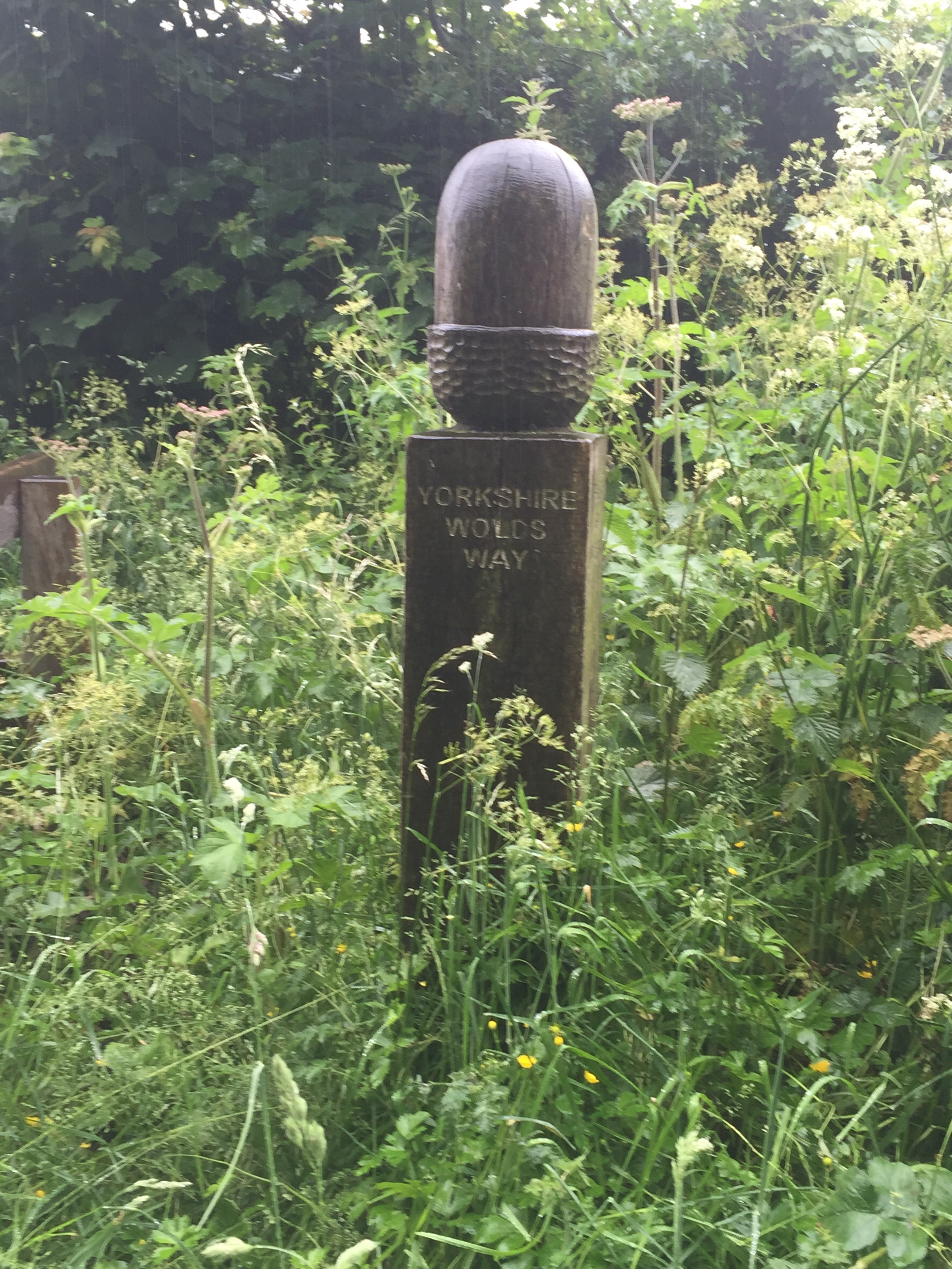
After a very ‘interesting’ breakfast served in a basket delivered to our room and comprising plain and chocolate croissants, porridge in a pot (to have water added – ugh!), fruit and chocolate muffins (white and brown), we set off for a very short days walk (8 miles).  First we had to find the Wolds Way as we had turned off the route for Market Weighton and had walked in to the town along the road as it was so wet.  With the help of the compass and a lot of peering at the map, we identified our route out eventually and headed out across fields. 

We were amazed at how dry the grass was, given the rain yesterday, but we were extremely grateful.  After a couple of miles our boots had begun to dry out and we came to the gates of Londesborough park which were very grand.  Sadly the Elizabethan house has been long since demolished. 

Through the gates we passed a lovely gate house and continued on ahead through the park, and came across an historic deer shelter, thought to have been part of the original Elizabethan building …..  Very interesting – obviously deer were very well treated in Elizabethan times!


Walking out of the park through more grand gates we came to Londesborough village where I realised I had been before when I stayed at Flamborough Head with the girls last year.  Spooky!  Walking through the village, having sighted but failed to get a photo of the 11th century sundial and Anglo-Danish over the Norman south door of the church as it had been covered with mesh to keep the birds off  (so much for the aesthetics!) we admired the large estate houses and eventually came to a cross roads. 

We walked up the hill out of Londesborough and out onto a road that gave great views over the vale of York (if you could see over the hedge!) and three major power stations – Drax, Eggborough and Ferrybridge.


 Having escaped a near nasty collision between a speeding white van and large lorry coming the other way and us scrabbling onto the verge at the side of the road, we walked through a farm yard and then across country to the village of Nunburnholm.  We skirted the edge of a village and – rather oddly – the edge of a grassy field and started climbing up.  During the inevitable descent of the next field we were treated to some amazing swoops and twirls of a red kite.  Amazing!

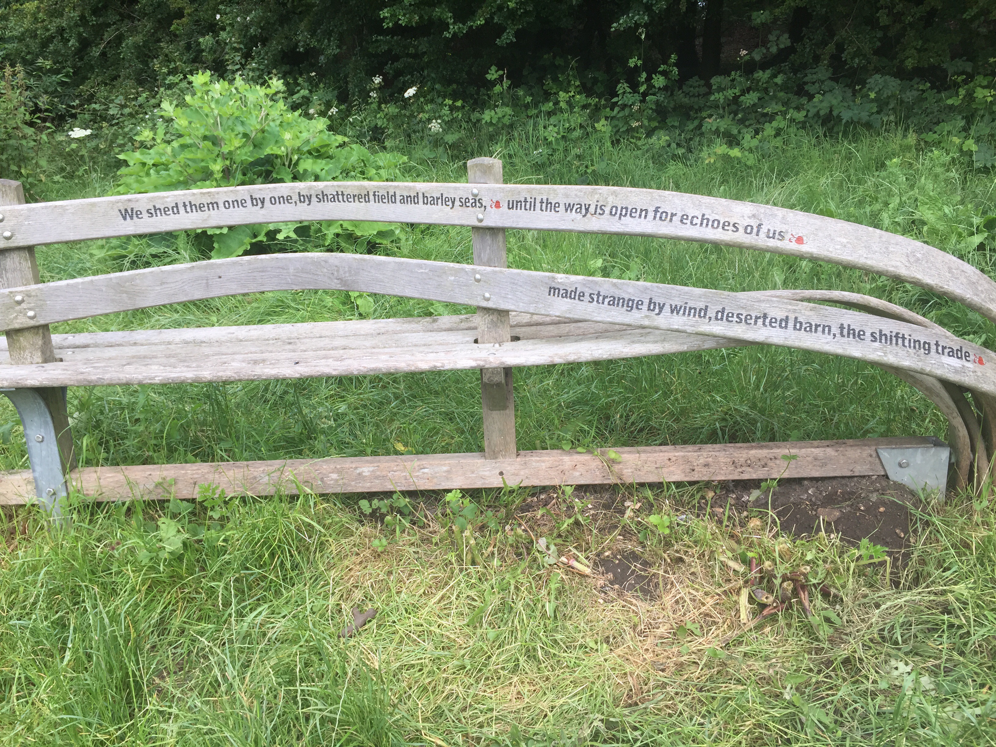
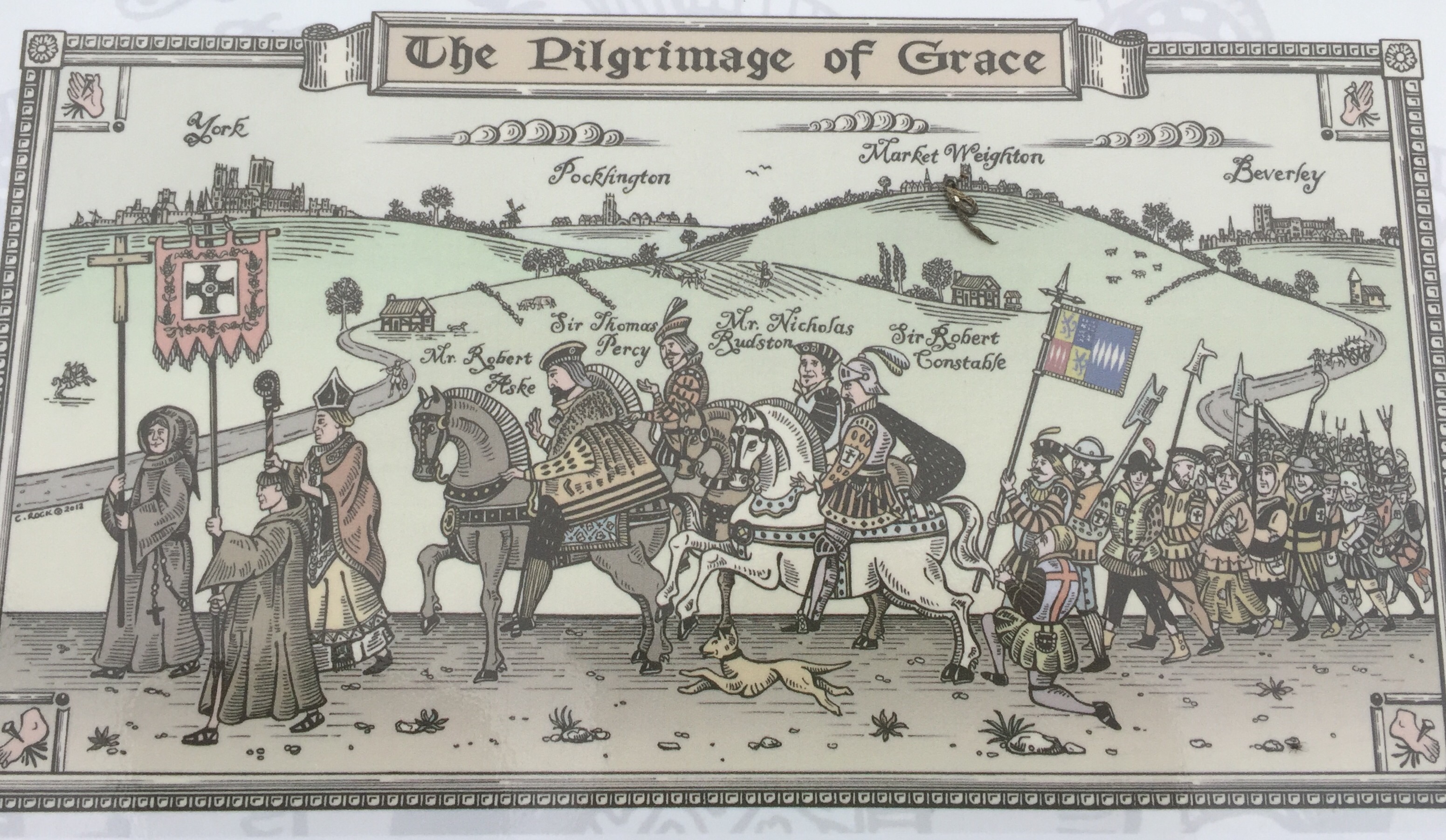
After crossing a minor road, skirting a small wood and crossing a meadow with young bulls in it, we walked along the edge of a corn field with more wonderful views and also an information board telling us about something called the Pilgrimage of Grace, which I had never heard of before.  Apparently this was an uprising of northern Catholics against Henry VIII’s dissolution of the monasteries. In the end there were 50,000 involved in the stand against the King.  Amazing and something I need to know more about!!


Nearby we were encouragingly told that it was only 49miles to go to Filey!  Great!


Shortly after this we passed through the farmyard of Low Warrendale Farm and after inspecting a barn full of piglets we wandered down the track to the road and took the road to Millington.  

As we were to arrive in the village before 2.00 pm, we both visualised and talked of the drink we were going to have at the pub shown on the map.   Now sometimes you are the pigeon and sometimes the statue – however today was not to be a pigeon day.  We arrived to find the  pub doesn’t open at lunch time and the Ramblers Rest (a very nice looking cafe) was closed due to a power cut…. C’est la vie!

South Cave to Market Weighton

First, the church that failed to appear from yesterday.  Brantingham Church.


Having rejoined the path just outside of South Cave (as it was not raining we did not take up the offer to be taken further along the route………) and set off along the path heading down hill.  The sky was ominously grey.  Having crossed a small beck, we started to climb and soon found ourselves walking along the edge of trees with, once again, a view of the Humber in the distance.  There were some amazing seats on the top of the hill from which to take advantage of the view.  


I had taken the precaution of wet weather trousers – which later proved to be a good move – but their rustle proved to eclipse somewhat the birdsong which was somewhat frustrating.  However, the walking was good and the path delightful. At the top of yet another rise we walked along the crest of the hill and then took a zig zag path down and were then on the disused Hull to Barnsley Railway line. After about half a mile we turned away on to a path along a fence, a reminder that a lot of the Wolds Way paths are over large country estate land. Just to endorse the point we came across an old stone marker of the Hunsley Fence which apparently noted the most northerly part of the Hunsley estate. 

 By now it was beginning to rain and we had been walking through wet grass for some time.  Before long the rain was torrential and was to continue for the rest of the day.  After crossing a number of fields, including an oil seed rape field now bereft of its acid yellow flowers but spotted with beautiful red poppies. 


We followed a long ‘dry’ valley (something of a misnomer today) walking for about a mile and a half along the valley floor and flanked by rising pasture on both sides.  It would have been magnificent on a sunny day.  As it was the bedraggled sheep looked at us as though we were mad!

We walked on.  The purists among us will be disappointed to learn that I did not spend too long looking for the dew pond that did not materialise at the bottom of a steep hill, which had immediately followed a long climb up.  Nor did I observe the the ‘clearly visible reminders’ of the late Iron Age Warriors – the Parisii. Instead we plodded on through the unlikely named Arras Farm (have we moved to France now I asked myself?)  and along long grassed meadow paths until we reached the Market Weighton Gap and then took the decision to walk along the road into Market Weighton, home of Britains tallest man…… who was 7ft 9 ins tall and 27 stone.  He was born in 1787 and died at 33.   

We found the Londesborpugh Arms in the Hogh Street.  It’s pillared entrance indicated better times but was a great port in almost a literal storm…..

Day 1 continued

The footpath was quite wide and sandy. At the beginning you could opt for the  ‘beech’ but it was shingle and not easy under foot.  The path option was preferred.  We walked under the bridge, with the thud of cars overhead, and soon came across an old chalk mill ………

Chalk is a key component of the wolds and has contributed to the landscape and what the land can be used for. Some of the oldest cultivated land in Britain is to be found here.   Water drains through chalk so the land quickly dries after rain and is never wet for very long. A great attraction for those early farmers!

It is chalk I think that also gives rise to the frequent evidence of ‘sweet betsy’ flowers along the edge of the path.  These were reminiscent of times spent playing as a child in the chalk pits of Kent. Apparently the chalk of the wolds here is from the same band of chalk that is evident in  Kent and makes the white cliffs of Dover  …….

As we continued along the path with the water lapping over the rocks to our left and trains passing just a couple of hundred yards away to our right, we came to North Ferriby, famous (well famous around here!?!) for the discovery of Bronze Age boats found buried in the muddy foreshore.  Apparently there were three of them and they are regarded as one of the most significant archaeological finds in Britain. You just never know what you are going to come across on these outings!

Following a brief conversation with one of the natives, we decided not to run the risk of being caught by the tide just along from this point so we turned inland.  We were soon to take in the wealth of the area,  passing huge houses with beautifully manicured gardens.  We soon reached a major road junction and having safely reached the other side it was into woodland as we struck out away from the Humber for a while.  Shortly after entering the wood our route started to gently rise.  Having left the Terrace Plantation we were into the neat grounds of the North Hull Scout Camp and then past a quarry, and along another plantation of trees. Occasionally there were sightings to our left of the broad Humber River continuing to track our path several miles away.  Our route skirted the edge of Welton village which we were tantalisingly told was the ‘prettiest’ Wold village (we will never know!) and we set out along the Welton Dale. Here there was a bank of trees to our left but to the right the trees cleared and a steep escarpment of grass accompanied us for probably half a mile. 


After crossing a narrow lane, a beautiful ivy covered house appeared on the horizon. This proved to be Wauldby Manor Farm, an extremely grand establishment.  We had promised ourselves our snack at Turtle Hill – only to find a group of about 20 young people munching on their sandwiches on the exact spot we had highlighted for our break.  I thought K stepped over them a little grudgingly……   They weren’t to know!  We settled for a quick munch by a gate at the end of the footpath just prior to walking along the lane towards Brantingham.  

It started to rain as we set off again in a way that you knew it was set in for the day.  Nonetheless it was a lovely walk.  The lane eventually turned back into a footpath lined with dog roses and elder flowers.  The hedgerows have definitely changed garb from our walks earlier in the year.  Only the cow parsley continues to wave in the wind.  

We probably got to see a little more of Brantingham than we should have (we missed the turn to the church) but it was worth it to see a little of the lovely old village houses.  The church was lovely too, despite the rain ……

We also took the opportunity to inspect a sheep bath that was close to the churn.  All very interesting.  Apparently the sheep were washed by hand and then went under a pole which made them duck under the water for a rinse!  
It was not far from here that the road started to descend into the South Cave valley – our stopping point for the night.  Our initial instruction of waiting in the pub to be collected and being taken to our accommodation was somewhat thwarted by the pub not being open and no telephone signal from the cafe next door.  However, I was able to observe the jolly hen party taking place in the tea room while Keith went out into the street to get a signal.  The bride-to-be certainly did not hold back on the cake!! 

The Wolds Way

Well here we are back on the road – or perhaps I should say – back on the footpath.  This morning we set out from Hessle in Yorkshire to walk the 79 miles of the Wolds Way. This being the final part of Keith’s 60th birthday celebration and intended to bring us down to earth – having started with a West End play, moved on to host lunch for 40 people at the Cinnamon Club, held a riotous dinner for the neighbours, followed by two luxurious day at Le Manoir.  We need grounding. 


So we set out just before the Humber Bridge on a grey Yorkshire June morning…….

To get ourselves back to reality.  We were seen off by the stalwart Julie and the rather sickly James (hope he is better soon) and walked along the path beside the Humber Estuary. We were off.